Scenic Drives for Early Oct from NH to ME
This started as a scenic drive about what you can find on 3 October in Northern New Hampshire and Maine. But Lisa and I have changed the focus to the several smaller day trips that you can make based on your travel needs.
Most of the images in this article were from Oct 3, 2013. Those on Route 113 are from 2017 through 2020.
This is one of my long drives to take in autumn. We left Salem on 3 October and drove for 479 miles and we left before 7 AM and returned 14 hours later. But for you, you can make this a simple 88-mile trip by starting and stopping in Conway New Hampshire. OR 200 miles (a real full day) again starting and ending in Conway NH and going into Maine. Confused?
Trip 1 – 88 Miles and a minimum of 8 stops
You can pick up a VT/NH Gazetteer in my Amazon Store and Also the Maine Gazetteer to map out this trip.
For the short 88-mile trip: you leave Conway NH on Route 16 and proceed to Jackson New Hampshire and you could spend an hour in Jackson by itself. click through to check this article on exploring Jackson, its covered bridge, restaurants, pumpkin people, and more.
From Jackson New Hampshire, you will jump back on Route 16 heading North to Pinkham Notch and, Mount Washington. You could stop and hit the Mount Washington Auto Road (MWAR) and you can read about that here.
IF you are brave enough to take the MWAR, You start and finish back on Route 16. you turn left and head to Gorham. Once you hit Gorham you will make a right onto Route 2 and cross into Maine (10-11 miles). You will turn South down Route 113 at Gilead Maine and follow it back to Route 302 and head west back to Conway. There are things to see in Gorham (train museum) and I left out some of the scenic stops along Route 13 but you can read this article or this article that details Route 113. Route 113 as noted brings you to Route 302 and heading West will bring you back to Conway and your starting point. This trip “COULD” only take 2-3 hours BUT! I would allow 6-8 hours to stretch your legs, grab a meal or two, snap a WHOLE BUNCH of pictures…
Trip 2 – 200 Miles and too many possible stops to list…
For this trip, you continue from Gorham on Route 16 continuing North. and you can add Milan State Park (Listed below) to your itinerary. Milan is about 15 miles past Gorham and there is a 3 story fire tower that gives you incredible panoramic sweeping visits to view.
Then you will continue North to Errol NH (last stop for gas) continuing east on 16 past Lake Umbagog (Photo OP) and proceed into Maine. You will be traveling through some incredible scenery and there are lots of places to get shots from the roadside. Watch your gas because as noted gas stations are far and few between this far north.
Once you cross into Maine you will travel to the north of Mooselookmegnutic Lake but don’t worry you will turn south on Route 17 and stop at the Height of Land (read more about it below) for an impressive sweeping vista of Lake Mooselookmeguntic and the surrounding hills. You will continue south on 17 till you get to Coos Canyon. This is another scenic location worth stopping at. I’ve written about both of these places so click the articles and read about those locations.
Back on 17, you will continue to Mexico (Maine, no passport needed) and through Rumford Maine to pick up Route 2 west (to New Hampshire). Once you pass Newry ME look for the signs for Sunday River Resort and turn onto Sunday River Road. Take it past the resort until you reach the Sunday River covered bridge. photograph it and turn around and back down to Route 2 and west to Gilead ME. From here you will pick up the previous trip and head south on Route 113 to Route 302 and back into Conway.
How Our Trip Differs From Yours. We did the WHOLE thing and then some…
As I always state, DO NOT DO WHAT I DO! Lisa and I started and stopped in Salem Massachusetts and we went ALL the way up to Mooselookmegnutic Lake and came back South to pick up Route 16, I-95 south to Salem. (I was also in my 50s when I did this and while my brain says I can do it, Lisa is there to stop me from trying it. But we did this entire trip in a little over 14 hours which makes our trip soooo much longer than we want YOU to actually drive in a day.
So we drove north on Route 95 to Route 16, following it through Jackson to Gorham. We then crossed on 16 into Maine, heading towards Rangeley but due to the time of day, we headed south on Route 17.
We stopped at a couple of favorites like the Height of Land and Coos Canyon before arriving in Rumford Maine. Lisa probably pointed out that the Sunday River covered bridge is just two towns off Route 2 (Newry ME) so we headed in that direction. Since we were on our way home I was probably thinking of crossing back over into NH. Lisa probably asked me “Have we been on Route 113?” which was just ahead at Gilead and I said no and today, Oct 3rd, would be the first time to take Route 113 (read about that here).
What follows are some of the highlights of this long route and I know now that I missed SO much because over the years I have tried to get off Route 16 and explore further afield but the lure of the road I’m on keeps calling and I just have to see what is just around the next bend.
Even though Lisa and I dropped our weary heads on our pillows at home and not Conway. You? You can drop your head onto pillows at many places along this trip. You could or should make this at least, a two-day trip.
Gorham New Hampshire.
Gorham, New Hampshire, nestled in the White Mountains, is a charming gateway for outdoor enthusiasts and nature lovers. Its proximity to the scenic beauty of the White Mountain National Forest makes it a popular destination for hiking, biking, and wildlife viewing, while the nearby Presidential Range offers stunning vistas and challenging trails for all skill levels.
Gorham is also a favorite stop for travelers heading to Mount Washington, the highest peak in the Northeast, where they can experience the Cog Railway, drive the famous Auto Road, or hike to the summit. In winter, Gorham transforms into a snow-covered wonderland, with snowmobiling, cross-country skiing, and snowshoeing becoming the activities of choice.
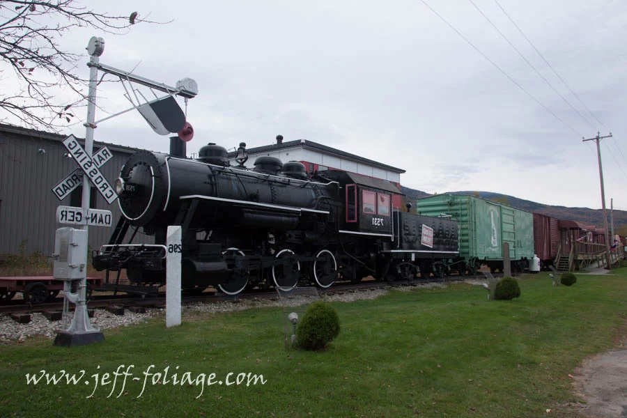
Tourists are drawn to Gorham not only for its natural beauty but also for its welcoming atmosphere and convenient amenities. The town features a selection of cozy inns, lodges, and restaurants catering to visitors. The Androscoggin River, running through town, offers opportunities for kayaking and fishing, while Moose Tours provide an unforgettable chance to spot these magnificent creatures in their natural habitat. Whether seeking adventure or a peaceful retreat, Gorham offers year-round attractions that make it a perfect stop in the White Mountains region.
Milan Fire Tower
The drive up to the Milan Fire Tower in Milan, New Hampshire, takes you along a short dirt road, surrounded by dense forest As you ascend to the top of the hill you park at the Ranger Station. You don’t have to put money in but I like to drop 5 dollars in the day-use deposit even though I’m only stopping for the view and leaving, They have Yurts you can read if you want to stay the night.
The air feels crisper, and the trees seem to stretch endlessly toward the sky, creating a tranquil atmosphere. The road itself is gravel and dirt in some sections, but navigable for most vehicles. Along the way, you’ll pass through groves of pine, birch, and maple, and depending on the season, you might catch glimpses of brilliant fall foliage or serene snow-covered landscapes. As you near the fire tower, the road narrows, and you’ll find a small parking area from which the tower is a short, walk up the hill (You can’t miss it).
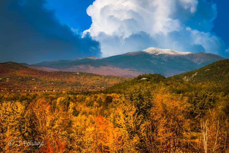
Once you reach the top and climb the historic Milan Fire Tower, you are greeted with an extraordinary 360-degree panoramic view of northern New Hampshire and beyond. To the south, the White Mountains dominate the horizon, with the Presidential Range rising majestically in the distance. On a clear day, you can spot Mount Washington, often capped with snow, standing as the region’s crown jewel. To the north and west, you’ll see the rolling hills and valleys of the Great North Woods, while to the east, the forested expanse stretches toward the Maine border. The views from the tower, especially during the peak foliage season, are breathtaking, with a sea of vibrant colors as far as the eye can see. Whether during sunrise, sunset, or a crisp autumn afternoon, the view from the Milan Fire Tower is one of the most stunning and peaceful in New Hampshire’s North Country. You can read about this scenic overlook in this article on day-tripping in Northern New Hampshire.
Height of Land – Maine
The Height of Land near Rangeley, Maine, off Route 17 offers one of the most iconic and breathtaking views in the Northeast, especially during the autumn season. As you crest the hill, the landscape unfolds dramatically before you, revealing an expansive vista of MooselookMeguntic Lake and the surrounding mountains.
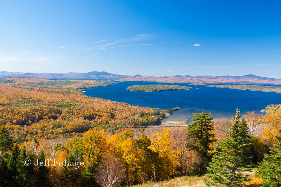
In fall, the scene is nothing short of spectacular, with a vibrant tapestry of orange, red, and gold foliage stretching across the rolling hills and the shores of the lake. The deep blue of MooselookMeguntic Lake contrasts vividly with the warm autumn colors, while small islands dot the water, adding to the picturesque beauty. The panoramic view is so captivating that it often leaves visitors in awe, making it a must-see stop for anyone traveling through Maine during peak foliage season.
These fall colors were some of the best that we had seen so far and we soon took our leave, heading south on Route 17. Next up was a stop at Coos Canyon.
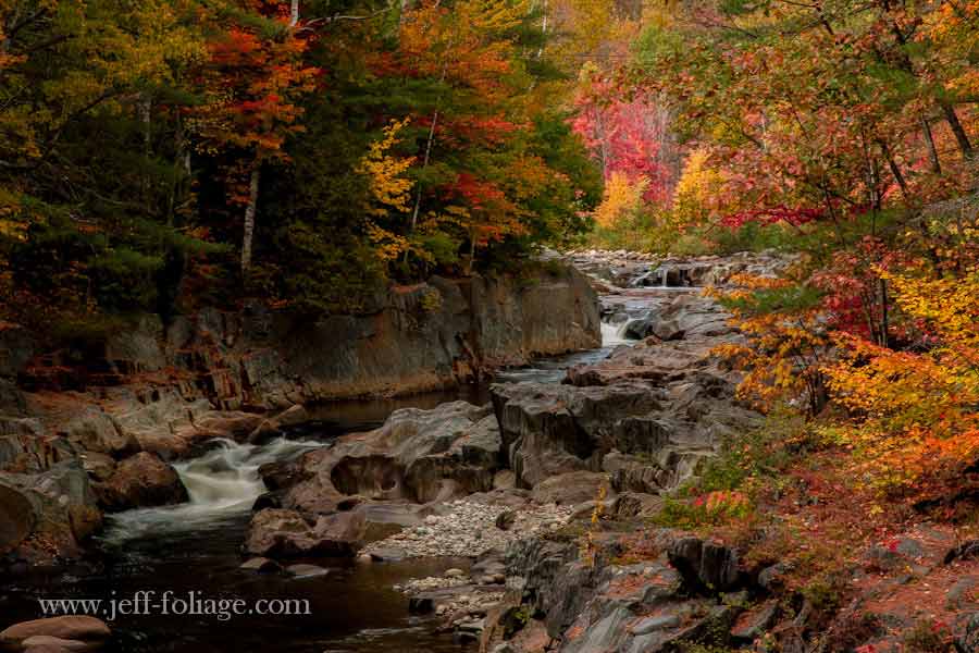
Coos Canyon on 3 Oct
Coos Canyon, located off Route 17 in Maine, is a stunning natural gorge that becomes even more enchanting in autumn. As you approach, the canyon’s dramatic rock formations and cascading waterfalls are framed by a brilliant display of fall foliage, with the trees along the Swift River ablaze in vibrant shades of red, orange, and yellow
We stopped in Coos Canyon and the colors were outstanding on 3 October. How good the fall colors will be for you will depend on when you arrive and how the temps are running. In a normal year, the fall colors will be more or less like this during the first week in Oct (in a slow-burn year, they will be a week later)
The cool autumn air and the sound of rushing water create a peaceful ambiance, perfect for a scenic stop or a short hike. You will find several picnic tables around this stop. Visitors can explore the canyon’s rocky ledges, and walk along the river. The contrast of the colorful leaves against the clear, bubbling waters makes Coos Canyon an unforgettable autumn destination, ideal for photographers and nature lovers alike.
We did not stop on this particular day but as I have said I have stopped several times over the years. but Lisa pointed out the fact there was a covered bridge coming up and when we saw the Sunday River covered bridge sign so we diverted to the Sunday River Covered Bridge.
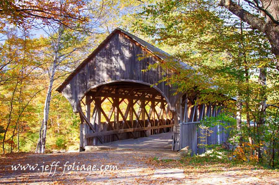
Sunday River or Artists covered bridge – Newry Maine
It’s only about 4 miles after you turn onto Sunday River Road. There is a fair bit of parking around the bridge. The bridge was moved off the road (or the road was moved to bypass the bridge.
After photographing the bridge we turned back south and picked up Route 2 west once again. As I stated up top, Lisa probably saw the road listed in the Gazetteer and asked if we had been on this road. So we started our first trip down Route 113 in 2013 (9 years ago… YIKES, I’m getting old)
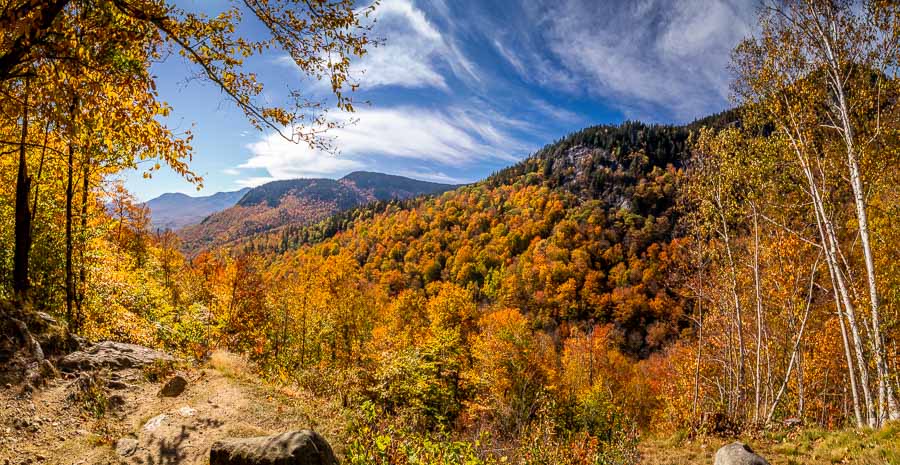
Route 113, Less Traveled Gem & 34 miles long
Route 113 is an outstanding little road and in a few spots it’s a bit narrow but paved and it can be very colorful. If the Kancamagus is backed up this is a good substitute and it’s about the same length. From the start of Route 2 in Gilead Maine to the end which brings us back to Route 302. The total length is 34 miles. Below are a “Few” of the scenic points that Lisa and I have found along Route 113.
Wild River Road – 20 Oct 2017 (a slow-burn year)
Your First photo-op can be if you jump off on Wild River Road. WRR is a straight and easy road to take but it does dead-end just under 5 miles out in the New Hampshire wilderness. There are a couple of trailheads that you can park at and please do your research on them before you just head out into the woods. Plus you can get shots of the fall colors along the river.
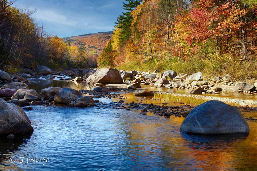
The road follows the Wild River but as seen here is not all that wild in October. This was a dry summer and we had just had a heatwave a couple of weeks prior, so the river was just barely flowing. Continuing on we come to Evan’s Notch Scenic Lookout.
Evan’s Notch 21 Sept and 20 Oct
The road starts and stays paved the whole length (unless you get off on side roads) and it can be narrow with limited pull-off opportunities. I have managed to stop and “grab” some shots but for the most part, your Second photo-op is the pull-out at Evan’s Notch.
You don’t want to get here TOO early. You also don’t normally have to wait till 20 Oct as I found good solid color on 6 October 2020. The day we were there in 2020 was overcast with very low clouds running through the valley. Also, remember 2020 was an early year for the color.
The Brickett Place
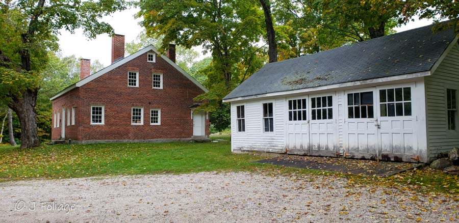
There are trails that lead off from here for exploring and there is sometimes a Ranger here to offer assistance or suggestions. Just across the road from Brickett Place is the entrance to the Basin Campground.
The Basin – 6 October 2020
I didn’t find the Basin till my later trips. My first trip had ended (2013) and I was writing the trip up, I looked in Google Maps to check my info and I saw a splash of blue across the border in New Hampshire. I zoomed in and found the Basin campground. I actually came back with the CBS Sunday Morning crew in 2018 and we recorded my interview in that campground.
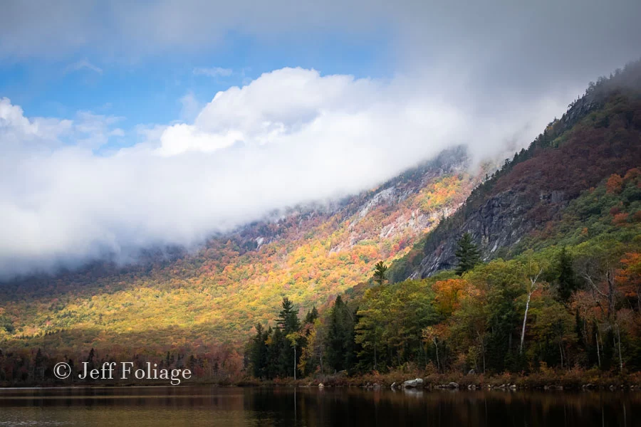
I loved the day that Lisa and I arrived there and it wasn’t totally overcast as I made my way down the shore to get a different aspect, The clouds parted a little and I was presented with this view.
As we left and continued south we will travel through Stowe and Freyburg Maine before crossing back into New Hampshire. Route 113 will drop you onto Route 302 and this will take you back to the outskirts of Conway.
Check this article on places to not miss on 1 October (in a slow-burn year make it 5 Oct)
Jeff Foliage Folger
Autumn is a state of mind more than a time of year – Jeff Foliage
Enjoy your images and comments. How about a scenic drive on highway 100 in Vermont. Planning a trip in early October and would enjoy your advise on sights not to be missed. Thanks
Enjoy your images and comments. How about a scenic drive on highway 100 in Vermont. Planning a trip in early October and would enjoy your advise on sights not to be missed. Thanks
Thank you for the pictures and narrative, Jeff.
And thanks for stopping by as well!
Thank you for the pictures and narrative, Jeff.
And thanks for stopping by as well!